
 Mount Kilimanjaro was first climbed in 1889 by a German geologist Hans Meyer, an Austrian climber Ludwig Purtscheller and a local guide Yohani Kinyala Lauwo.
On Meyer’s first attempt in 1887, he made it to the base of Kibo but had to turn around there. He encountered thick snow and ice walls and did not have equipment for heavy snow and ice.
He made a second attempt in 1888 that was also unsuccessful. But it was not due to the mountain itself, but because Meyer was captured and held as a prisoner by locals as part of the Abushiri Revolt, when the Arab and Swahili population rebelled against German traders. He was freed after a ransom was paid.
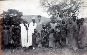
Meyer finally succeeded in 1889. His support team included a guide, two local tribe leaders, nine porters, and a cook. They reached the summit on the southern rim of the crater. The Marangu route closely follows Meyer’s groundbreaking path up and down Kilimanjaro.

The equator is an imaginary line that divides the Northern Hemisphere and Southern Hemisphere. It passes through the exact center of the Earth and divides it in half.
The equator is distinct from the rest of the globe due to the high amount of solar radiation it receives. The equatorial climate stays nearly the same year-round. The dominant patterns here are either warm and wet or warm and dry.
Mount Kilimanjaro lies just 205 miles from the equator, in the country of Tanzania. When early explorers reported seeing glaciers on the top of Kilimanjaro, people did not believe them as they thought it was impossible for ice to form so close to the hot, equatorial sun. Scientists now believe that the glaciers shrink and then regrow during the planet’s ice ages.
Elevation: 5,895 m
Location: Kilimanjaro Region, north east Tanzania
Topo map: Kilimanjaro map and guide by Wielochowski
Last eruption: Between 150,000 and 200,000 years ago
First ascenders: Ludwig Purtscheller, Hans Meyer
Continent: Africa